Date Updated:
Manaslu Circuit Trek Map (Complete 2026 Guide)
Table of Contents
- Introduction
- Manaslu Circuit Trek Map (Overview)
- Key features shown on the map
- Manaslu Circuit Trek Map
- Elevation Profile of the Manaslu Circuit Trek
- General elevation pattern
- Manaslu Route Map Breakdown (Section by Section)
- 1. Soti Khola to Machhi Khola
- 2. Machhi Khola to Jagat
- 3. Jagat to Deng
- 4. Deng to Namrung
- 5. Namrung to Lho to Samagaon
- 6. Acclimatization at Samagaon
- 7. Samagaon to Samdo
- 8. Samdo to Dharmasala (Larke Phedi)
- 9. Dharmasala to Larke La Pass to Bhimthang
- 10. Bhimthang to Tilje to Dharapani
- Alternative Routes and Side Trails
- Chumling and Chhekam Paro Route (Gateway to Tsum)
- Local Village Extensions
- Connection to the Annapurna Circuit
- Section Difficulty Overview
- Safety and Seasonal Notes
Introduction
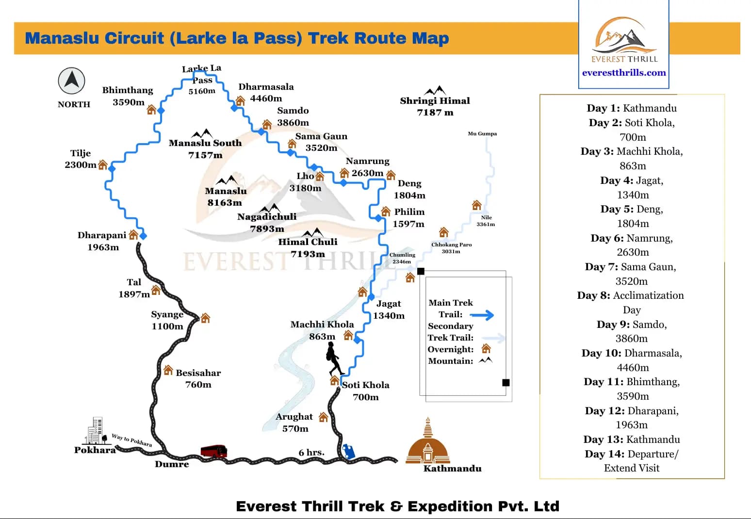
The Manaslu Circuit Trek is one of Nepal’s most scenic and remote Himalayan routes, circling Mount Manaslu and crossing the high Larke La Pass at 5160 meters. Understanding the trek map helps you visualize how the trail moves from warm river valleys to alpine basins and finally into glacial high mountain terrain. This guide explains the exact route shown on the Everest Thrill Manaslu map and breaks down each section from Soti Khola to Dharapani.
For complete planning details, explore the Manaslu Travel Guide.
Manaslu Circuit Trek Map (Overview)
The Everest Thrill Manaslu Circuit map outlines the official trekking route beginning at Soti Khola and ending at Dharapani. The map highlights all major overnight villages, elevation points, Himalayan peaks, and the high crossing of Larke La Pass.
Key features shown on the map
- Main trekking trail marked clearly in blue
- Overnight villages including Machhi Khola, Jagat, Deng, Namrung, Samagaon, Samdo, Dharmasala, and Bhimthang
- Major peaks such as Manaslu (8163 m), Himal Chuli (7193 m), and Shringi Himal (7187 m)
- Road networks connecting Kathmandu, Arughat, and Soti Khola
- Full descent into Tilje and Dharapani, where the route connects to the Annapurna trail
Permit zones and required documents are explained in the Manaslu Trek Permits Page.
Manaslu Circuit Trek Map
Elevation Profile of the Manaslu Circuit Trek
General elevation pattern
- Low region: Soti Khola (700 m) to Jagat (1340 m)
- Mid altitude: Deng (1804 m), Namrung (2630 m), Lho (3180 m), Samagaon (3520 m)
- High altitude zone: Samdo (3860 m) to Dharmasala (4460 m)
- Highest point: Larke La Pass (5160 m)
- Descent: Bhimthang (3590 m) to Tilje (2300 m) to Dharapani (1963 m)
For a full altitude breakdown, see Manaslu Height and Altitude Page.
Manaslu Route Map Breakdown (Section by Section)
Below is the complete breakdown of the Manaslu Circuit trek route from Soti Khola to Dharapani. The trek typically takes 12 to 16 days. With the Everest Thrill package, the trip can be completed in 14 days. You can check our Manaslu Circuit Trek itinerary or even request a custom one.
1. Soti Khola to Machhi Khola
Altitude: 700 m to 863 m
The trek begins with a warm, humid walk along the Budhi Gandaki River. You pass through forested hills, narrow cliffside paths, and several suspension bridges, with small settlements scattered throughout the valley.
2. Machhi Khola to Jagat
Altitude: 863 m to 1340 m
The trail continues north toward Dobhan and the lower Philim region. The valley opens slightly, the terrain becomes more balanced, and the elevation gain remains moderate as you make your way toward the stone-paved village of Jagat.
3. Jagat to Deng
Altitude: 1340 m to 1804 m
This section features terraced farmland, narrow gorges, and beautiful hillside scenery. You pass Philim at 1597 m, an important cultural settlement, and reach Deng, where the landscape begins to feel more remote and cool.
4. Deng to Namrung
Altitude: 1804 m to 2630 m
A significant elevation gain begins here. The trail leads through dense forests, steep climbs, and cooler temperatures as you rise into mid-altitude terrain. Mountain views gradually begin to open up.
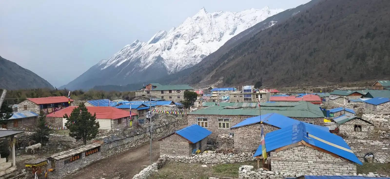
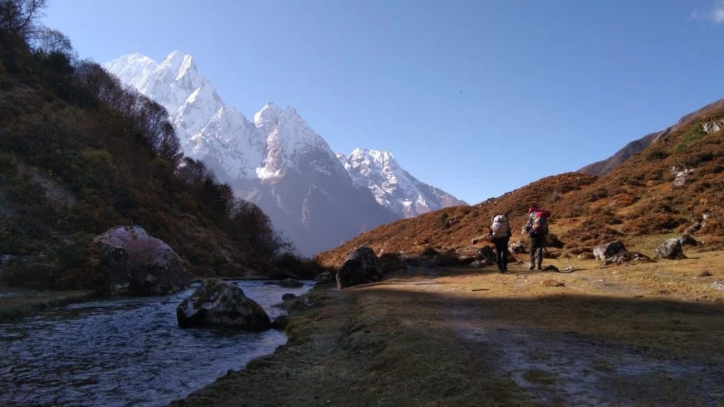
5. Namrung to Lho to Samagaon
Altitude: 2630 m to 3520 m
This is one of the most scenic stretches of the entire trek. Villages like Lho (3180 m) and Shyala offer panoramic views of Manaslu and surrounding peaks. Samagaon stands as a major cultural hub with traditional houses, monasteries, and access to high-altitude views.
6. Acclimatization at Samagaon
Altitude: 3520 m
Trekkers usually spend a full day in Samagaon to acclimatize. Side hikes to viewpoints, monasteries, and Manaslu Base Camp are popular. More elevation insights are available on the Manaslu Altitude and Height Page.
7. Samagaon to Samdo
Altitude: 3520 m to 3860 m
The trail rises gradually across wide open valleys and yak pastures. Samdo is a Tibetan-influenced settlement close to the border and serves as another ideal acclimatization stop for high-altitude preparation.
8. Samdo to Dharmasala (Larke Phedi)
Altitude: 3860 m to 4460 m
A short but steep climb leads to Dharmasala, the final overnight point before crossing Larke La. The area is exposed, cold, and surrounded by rugged high-mountain terrain.
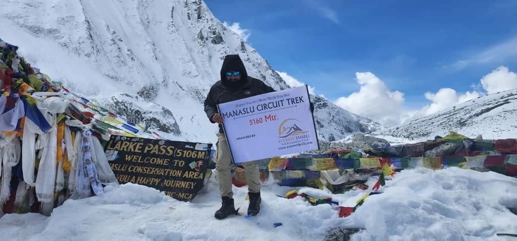
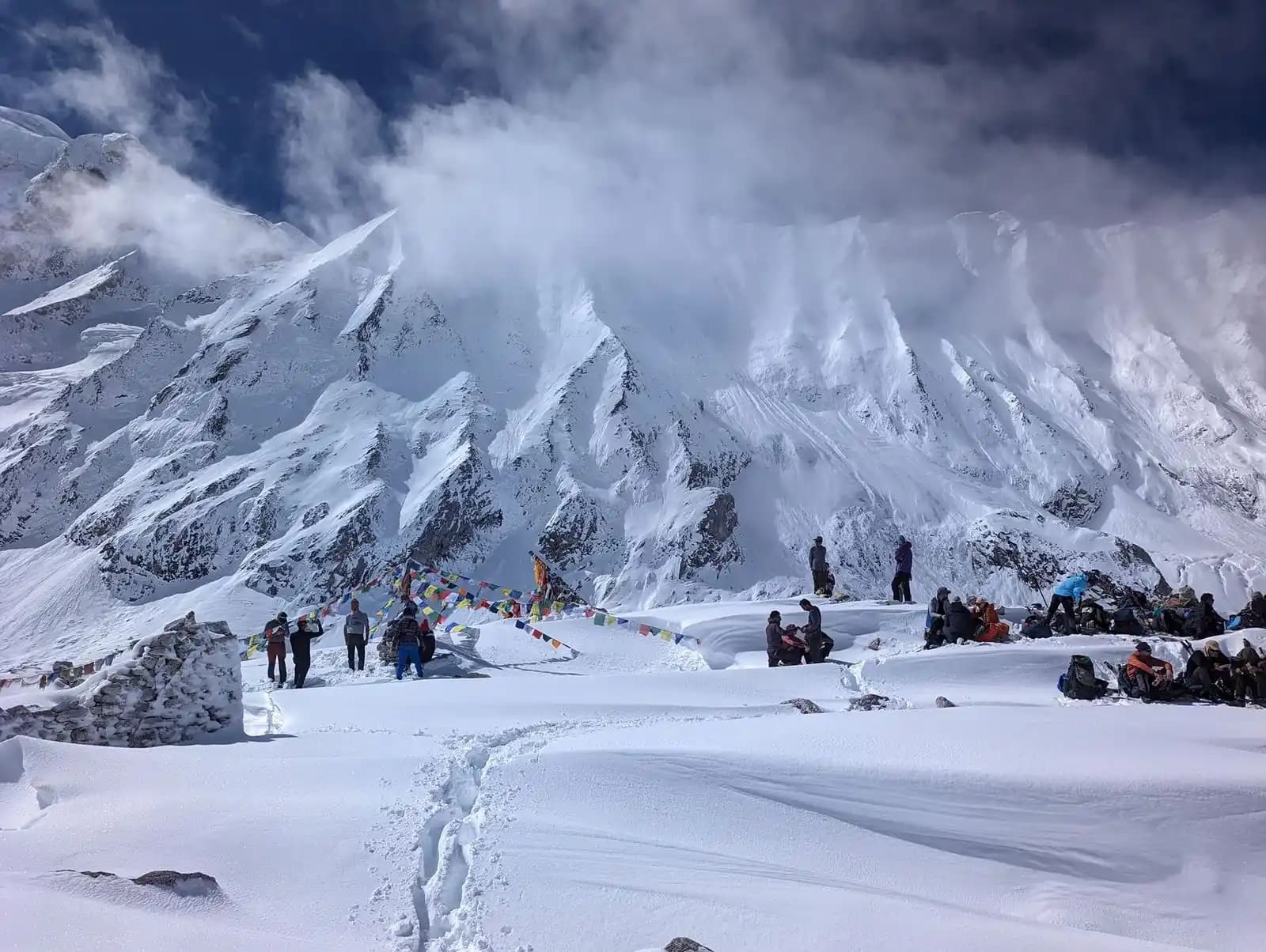
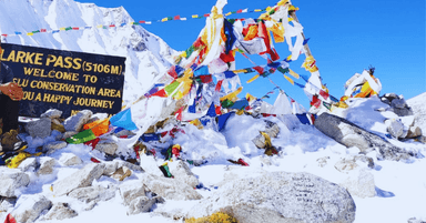
9. Dharmasala to Larke La Pass to Bhimthang
Altitude: 4460 m to 5160 m down to 3590 m
This is the hardest and most rewarding day of the trek. The ascent to Larke La Pass (5160 m) is challenging but offers remarkable Himalayan views. A long descent brings you into the alpine meadows of Bhimthang. For an overview of how demanding this part of the trail can be, refer to the Manaslu Trek Difficulty Page.
10. Bhimthang to Tilje to Dharapani
Altitude: 3590 m to 2300 m to 1963 m
The trail drops into lush forests and farmland as you head toward Tilje and then Dharapani. This final stretch completes the circuit and connects directly to the Annapurna region.
Alternative Routes and Side Trails
The Everest Thrill Manaslu Circuit map includes a few optional side trails that complement the main route and offer added exploration opportunities.
Chumling and Chhekam Paro Route (Gateway to Tsum)
A secondary trail branches near Philim and Chumling, marking the lower access toward the Tsum region. Trekkers who want a cultural extension can follow this path to begin the optional Tsum Valley Trek, which adds remote monasteries, traditional villages, and peaceful landscapes to the journey.
Local Village Extensions
Short side paths toward nearby settlements are shown for brief cultural detours, acclimatization walks, or visits to viewpoints and monasteries.
Connection to the Annapurna Circuit
From Bhimthang, the trail continues to Tilje and Dharapani, where the Manaslu Circuit naturally merges with the Annapurna trekking route.
Section Difficulty Overview
| Section | Difficulty | Notes |
|---|---|---|
| Soti Khola to Jagat | Moderate | Warm, humid, narrow paths |
| Jagat to Deng | Moderate | Terraced fields and cliffside sections |
| Deng to Namrung | Challenging | Significant altitude gain |
| Namrung to Samagaon | Moderate | Open alpine valleys |
| Samagaon to Samdo | Easy | Gradual climbing |
| Samdo to Dharmasala | Challenging | High altitude terrain |
| Larke Pass Day | Very Challenging | Steep ascent and long descent |
| Bhimthang to Dharapani | Moderate | Forested downhill trail |
For detailed information on the difficulty of the Manaslu trek in various sections, check our manaslu difficulty page.
Safety and Seasonal Notes
Trekkers should be aware of the following risk factors along the route:
- Narrow cliff paths around Dobhan and Philim
- Possible landslide zones between Soti Khola and Jagat
- Snow and ice around Larke La Pass
- Glacier influenced trails near the high pass
- Rapid weather shifts in the upper Manaslu region
Season based trail conditions are covered in detail on the Best Time for Manaslu Circuit Trek Page.
The Manaslu Circuit Trek offers a rich mix of landscapes, culture, and high mountain scenery. With a solid understanding of the route and the map, you can plan your days confidently and move through each section at a comfortable pace.
If you want a well-planned itinerary that follows the exact route shown on this map, you can explore our full Manaslu Circuit Trek package for guided support, permits, logistics, and a safe pace across Larke La.
About Author
Amir Adhikari is the Founder and Trip Curator of Everest Thrill Trek and Expedition. With 10+ years of experience in Nepal’s competitive tourism sector, he is a recognized expert in designing safe, personalized, and high-thrill Himalayan itineraries. His dedication to responsible travel and creating authentic experiences has positioned Everest Thrill as a leading specialist for Everest, Annapurna, and off-the-beaten-path adventures.
Manaslu Circuit Trek
USD 1215/per person